Field observations and remote sensing techniques for evaluation of vegetal recovery after different wildfire severity in a Mediterranean ecosystem
Abstract
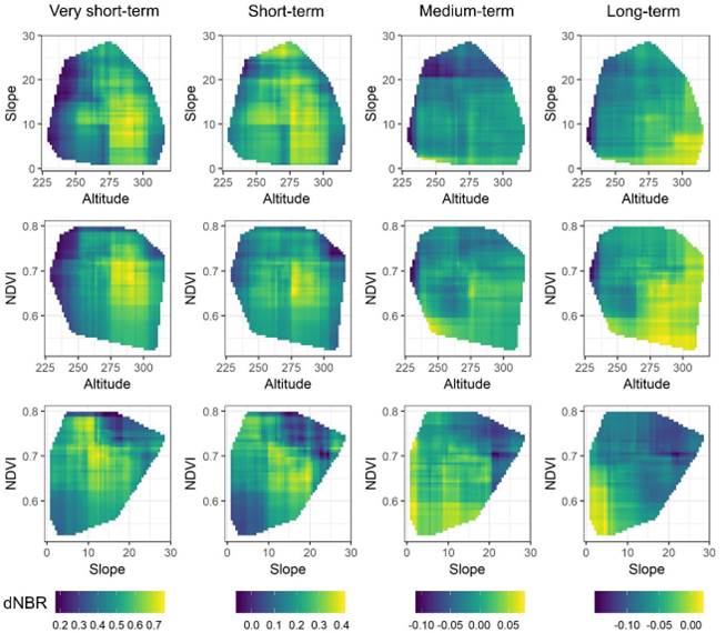
Many studies of Mediterranean ecosystems have analyzed vegetation recovery after a wildfire based on fieldwork or remote sensing; however, only a few have adopted a multi-approach assessment. The aim of this study is to determine the viability of a multi-approach using vegetation and remote sensing to observe vegetation recovery time in areas with different wildfire severity. The study area is located in a Mediterranean forest of North-east Spain. After a wildfire, low-, medium- and high- severities with an unburned control were delimited and inventoried at short-, medium- and long-terms using a 20-m transect; measurements were taken in a 1-m width. In each area, vegetal richness (S), diversity (H’) and density (D) were measured using fieldwork. The differenced Normalized Burnt Ratio (dNBR) and Mean Decrease Accuracy (%incMSE) were calculated and quantified. Both methods result to be accurate in studying plant density. The dNBR index decreases over time as an effect of the disappearance of fire disturbance. Topographic and vegetation variables help explain the fire severity at very-short and short-terms, while at medium- and long-terms any explanatory power is virtually lost. Partial dependence allowed us to identify those areas that suffered higher fire severity and vegetal evolution over time.
Marc Lemus-Canovas
Postdoctoral Researcher
I am enthusiastic about climate data processing, especially using R!